IT
°F
Cambia le tue misure
Meters
Feet
°C
°F
km/h
mph
kts
am/pm
24-hour
Le tue impostazioni sono state aggiornate
Cambia la lingua
Deutsch
Español
Italiano
Nederlands
中文
English
Français
日本語
Português
Oggi
7 giorni
Meteo
Pesca
Mare
Maree in
United States
Maree in
South Carolina
Maree in
Georgetown County
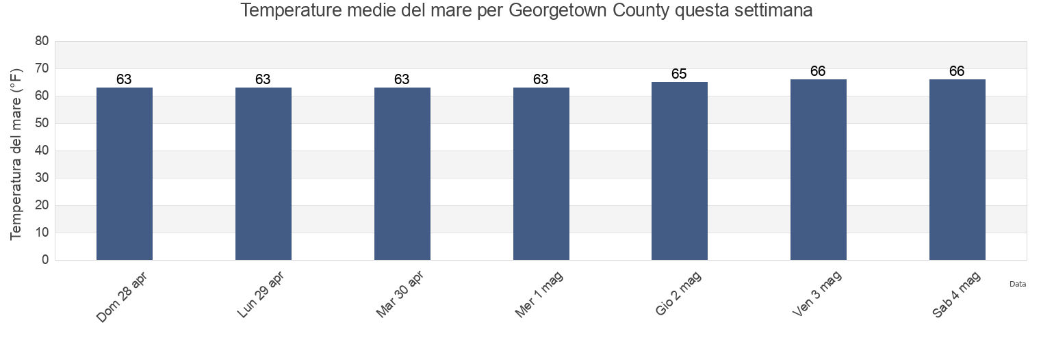
Temperatura del mare di Georgetown County
Temperatura del mare a Georgetown County questa settimana
Ulteriori previsioni di maree e informazioni marine per Georgetown County
Le maree oggi
Maree questa settimana
Tempo metereologico
Meteo pesca
Regioni e città di Georgetown County, South Carolina, United States
Allston Creek
Garden City Pier (ocean)
Oyster Landing (N. Inlet Estuary)
Arundel Plantation
Georgetown
Oyster Landing Crab Haul Creek North Inlet
Bennet's Dock
Georgetown Lighthouse
Pawleys Island
Bennets Dock Pawleys Island Creek
Georgetown Sampit River
Pawleys Island Pier (ocean)
Black River (south Of Dunbar)
Hagley Landing
Pee Dee River swing bridge
Brown Island (South Santee River)
Holly Grove Plantation
Pleasant Hill Landing (Santee River)
Mostra più località
Brown Island South Santee River
Jacobs Wharf
Pleasant Hill Landing Santee River
Bucksport
Lafayette swing bridge Waccamaw River
Rabbit Island northwest of
Bull Creek Entrance
Litchfield Beach
Range D off Mosquito Creek
Butler Island 0.3 mile south of
Litchfield Beach Bridge
Sampit River entrance
Cape Romain
Little Bull Creek Entrance (Bull Creek)
Smith's Dock
Cape Romain (46 Miles East Of)
Little Bull Creek Entrance Bull Creek
South Island Ferry (Intracoastal Waterway)
Cape Romain 46 Miles East Of
Lower Topsaw Landing
South Island Plantation
Captain Alex's Marina
Magnolia Beach
South Of Sam Worth Game Management Area
Captain Alexs Marina Parsonage Creek
Mc Clellanville Jeremy Creek
South Santee River (Highway 17 Bridge)
Carr Creek (1 mile above entrance)
Mcclellanville (Jeremy Creek)
South Santee River entrance
Carr Creek 1 Mile Above Entrance
McClellanville Jeremy Creek
The Pier (Pawleys Island)
Casino Creek
Midway Inlet North (Pawleys Island)
Thoroughfare Creek Entrance
Casino Creek ICWW
Midway Inlet North Pawleys Island
U S Highway 17 Bridge South Santee River
Cedar Island (North Santee Bay)
Minim Creek Entrance (North Santee Bay)
U.S. Highway 17 Bridge South Santee River
Cedar Island North Santee Bay
Mt Pleasant Plantation Black River
Waccamaw River Entrance
Cedar Island Point (South Santee River)
Mt. Pleasant Plantation (Black River)
Wachesaw Landing
Cedar Island Point South Santee River
Mt. Pleasant Plantation Black River
Ward's Dock
Clambank Creek (North Inlet)
Murrells Inlet
Wards Dock Pawleys Inlet
Clambank Creek Goat Island North Inlet
North Santee
Weymouth Plantation
Divine's Dock
North Santee Bridge
Windsor Plantation (Black River)
Frazier Point
North Santee River entrance
Windsor Plantation Black River
Frazier Point south of
North Santee River Inlet
Winea Plantation (Black River)
Frazier Point west of
Oaks Creek (0.5 Mi. Above Entrance)
Winea Plantation Black River
Garden City Bridge (Main Creek)
Oaks Creek (Upper End)
Winyah Bay Entrance (south Jetty)
Garden City Bridge Main Creek
Oceanside Beach
Yauhannah Bridge
Previsioni di maree vicino a Georgetown County
Georgetown
Windsor Plantation Black River
Windsor Plantation (Black River)
Pee Dee River swing bridge
Georgetown Sampit River
Lafayette swing bridge Waccamaw River
Waccamaw River Entrance
Sampit River entrance
Jacobs Wharf
Butler Island 0.3 mile south of