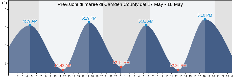
Venerdì 26 aprile 2024, 20:48 EDT (GMT -0400). Adesso a Camden County la marea è in discesa. Come si può vedere dal grafico, la marea più alta di 7.22ft è alle 23:29 e la marea più bassa di 0.33ft è stata alle 05:42 Clicca qui per vedere gli orari delle maree di Camden County per questa settimana.
La prossima alta marea è alle
23:29
La prossima bassa marea è alle
06:23
Tavola delle maree Camden County
| Giorno | Tavola delle maree Camden County |
|
||||
|---|---|---|---|---|---|---|
| 1ª marea | 2ª marea | 3ª marea | 4ª marea | |||
| ven 26 | 05:42 ▼ 0.33 ft | 11:06 ▲ 6.23 ft | 17:31 ▼ 0.33 ft | 23:29 ▲ 7.22 ft |
▲ 06:46 | ▼ 20:02 |
| sab 27 | 06:23 ▼ 0.66 ft | 11:47 ▲ 6.23 ft | 18:10 ▼ 0.66 ft | ▲ 06:45 | ▼ 20:02 | |
| dom 28 | 00:10 ▲ 7.22 ft | 07:08 ▼ 0.66 ft | 12:31 ▲ 5.91 ft | 18:56 ▼ 0.66 ft |
▲ 06:44 | ▼ 20:03 |
| lun 29 | 00:57 ▲ 7.22 ft | 08:00 ▼ 0.98 ft | 13:20 ▲ 5.91 ft | 19:50 ▼ 0.66 ft |
▲ 06:43 | ▼ 20:04 |
| mar 30 | 01:48 ▲ 7.22 ft | 08:57 ▼ 0.98 ft | 14:15 ▲ 6.23 ft | 20:55 ▼ 0.98 ft |
▲ 06:42 | ▼ 20:04 |
| mer 1 | 02:46 ▲ 7.22 ft | 09:58 ▼ 0.98 ft | 15:16 ▲ 6.23 ft | 22:05 ▼ 0.98 ft |
▲ 06:41 | ▼ 20:05 |
| gio 2 | 03:50 ▲ 6.89 ft | 10:57 ▼ 0.66 ft | 16:21 ▲ 6.56 ft | 23:14 ▼ 0.66 ft |
▲ 06:40 | ▼ 20:06 |
Orari migliori per pescare a Camden County oggi Giornata media per la pesca
Maior horário de pesca
Dalle 22:00 alle 00:00
Transito lunare (Luna sopra)
Menor horário de pesca
Dalle 07:41 alle 08:41
Tramonto della luna
Dalle 22:30 alle 23:30
Sorgere della luna
Clicca qui per vedere meteo pesca per Camden County questa settimana.
Tempo attuale a Camden County
Tempo metereologico
Piogge intermittenti in zona
Coperto dalle nuvole 84%
Temperatura
71°F
Min 68°F/Max 74°F
Vento
12 mph
Raffica di vento 20 mph
Umidità
66%
Punto di rugiada 59°F
Clicca qui per vedere il tempo di Camden County per la settimana
Il tempo oggi a Camden County
Il sole è sorto alle 06:46 e il sole è tramontato alle 20:02. Oggi ci sono state 13 ore e 16 minuti di sole e la temperatura media è di 72°F. In questo momento la temperatura dell'acqua è di 66°F. e la temperatura media dell'acqua è di 66°F.
Clicca qui per vedere il tempo di Camden County per la settimana
