IT
°F
Cambia le tue misure
Meters
Feet
°C
°F
km/h
mph
kts
am/pm
24-hour
Le tue impostazioni sono state aggiornate
Cambia la lingua
Deutsch
Español
Italiano
Nederlands
中文
English
Français
日本語
Português
Oggi
7 giorni
Meteo
Pesca
Mare
Maree in
United States
Maree in
California
Maree in
City and County of San Francisco
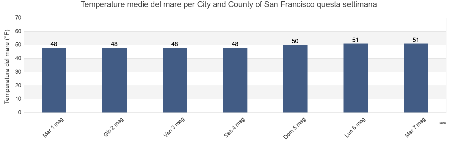
Temperatura del mare di City and County of San Francisco
Temperatura del mare a City and County of San Francisco questa settimana
Ulteriori previsioni di maree e informazioni marine per City and County of San Francisco
Le maree oggi
Maree questa settimana
Tempo metereologico
Meteo pesca
Regioni e città di City and County of San Francisco, California, United States
2nd Street
North Point Pier 35 north of
Point San Pablo midchannel
Alameda Estuary southeast end
Northridge Park
Point San Pedro
Alameda Naval Air Station
Oakland (Matson Wharf)
Point San Pedro 0.55 nmi. SE of
Alameda Radar Tower 0.9 nmi. SSW of
Oakland 7th St. Marine 0.6 nmi. SSW of
Point San Quentin
Alcatraz (North Point)
Oakland Airport
Point San Quentin 0.82 nmi. east of
Alcatraz Island
Oakland Airport southwest of
Point San Quentin 1.3 nmi. east of
Mostra più località
Alcatraz Island .8 mi E
Oakland Airport SW
Point San Quentin 1.9 mi E
Alcatraz Island 0.2 mile west of
Oakland Berth 67
Point San Quentin 1.9 miles east of
Alcatraz Island 0.5 mile north of
Oakland Harbor (Grove Street)
Point Simpson Angel I. 1.05 nmi. E of
Alcatraz Island south of
Oakland Harbor (Park Street Bridge)
Potrero Point
Alcatraz Island southwest of
Oakland Harbor Grove Street
Potrero Point 1.08 nmi. east of
Alcatraz Island W
Oakland Harbor High Street Bridge
Potrero Point 1.1 mi E
Angel Island .8 mi E
Oakland Harbor Park Street Bridge
Potrero Point 2 miles east of
Angel Island (East Garrison)
Oakland Harbor Webster Street
Pt. Blunt Angel I. 0.25 nmi. east of
Angel Island (west Side)
Oakland Harbor WebStreeter Street
Pt. Blunt Angel I. 0.8 mi. SE of
Angel Island 0.75 mile east of
Oakland Inner Harbor
Raccoon Strait
Angel Island East Garrison
Oakland Inner Harbor Channel
Raccoon Strait off Hospital Cove
Angel Island off Quarry Point
Oakland Inner Harbor Reach
Raccoon Strait off Point Stuart
Aquatic Park
Oakland Matson Wharf
Red Rock .1 E
Baker Beach
Oakland Middle Harbor
Red Rock 0.60 nmi. NNE of
Baker Beach (South Bay) 0.3 nmi. NW of
Oakland Outer Harbor Entrance LB 3
Red Rock east of
Baker s Beach
Oakland Pier
Richardson Bay Entrance
Bay Bridge Pier D
Oakland Yerba Buena Island
Richmond Inner Harbor
Bay Bridge Span B-C
Ocean Beach
Rincon Point
Berkeley Yacht Harbor
Ocean Beach (Outer Coast)
Rincon Point midbay
Berkeley Yacht Harbor .9 mi S
Ocean Beach Outer Coast
Roberts Landing (1.3 Miles West Of)
Blackies
Oyster Point 2.8 miles east of
Roberts Landing 1.3 Miles West Of
Bluff Point .1 mi E
Oyster Point Marina
Rockaway Beach
Bluff Point 0.1 mile east of
Pacifica State Beach
Sachuest Beach (2nd Beach)
Bluff Point 1.15 nmi. east of
Palisades Park
San Francisco
Brooklyn Basin
Pier 23
San Francisco (Golden Gate)
Candlestick Point
Pinole Point
San Francisco (North Point Pier 41)
Carquinez Bridge I-80
Pinole Point 1.18 nmi. west of
San Francisco Bar
Chevron Oil Company Pier Richmond
Pinole Point 1.2 mi W
San Francisco Bar north of ship channel
China Beach
Pinole Point 1.27 nmi. NNW of
San Francisco Bay Entrance (Golden Gate)
Corte Madera Creek
Pinole Point 1.42 nmi. NNW of
San Francisco Bay Entrance (Outside)
Coyote Point 2.3 nmi. NNE of
Pinole Point 3.0 nmi. WNW of
San Francisco North Point Pier 41
Crown Memorial State Beach
Pinole Point San Pablo Bay
San Francisco southern traffic lane N end
Davis Point (midchannel)
Pinole Shoal
San Francisco traffic separation zone buoy
Davis Point 1.0 nmi. NW of
Point Adams
San Leandro Channel
Emeryville Marina
Point Avisadero .3 mi E
San Leandro Channel (San Leandro Bay)
Fleming Point 1.7 mi SW
Point Avisadero 0.3 mile east of
San Leandro Channel San Leandro Bay
Fleming Point 1.72 nmi. SW of
Point Avisadero 0.6 nmi. ESE of
San Leandro Marina
Fort Cronkite Rodeo Beach
Point Avisadero 1 mi E
Sausalito
Fort Funston Beach
Point Avisadero 1 mile east of
Sausalito (Corps Of Engineers Dock)
Fort Point 0.3 nmi. west of
Point Avisadero 1.25 nmi. SSE of
Sausalito Corps Of Engineers Dock
Fort Point 0.5 nmi. east of
Point Avisadero 2 mi E
Seaplane Harbor
Golden Gate Bridge .8 mi E .
Point Avisadero 2 miles east of
Selby
Golden Gate Bridge 0.46 nm E of
Point Blunt .3 mi S
Sharp Park
Golden Gate Bridge 0.8 mile east of
Point Blunt .8 mi SE
Sierra Point 1.2 nmi. east of
Golden Gate Bridge 0.88 nm NE of
Point Blunt Angel I. 0.25 mile S of
Sierra Point 1.3 mi ENE
Golden Gate East Beach
Point Blunt Angel I. 0.5 nmi. SW of
Sierra Point 1.3 miles ENE of
Hercules
Point Bonita (Bonita Cove)
Sierra Point 4.4 mi E
Hercules (Refugio Landing)
Point Bonita 0.8 nmi. NE of
Sierra Point 4.4 miles east of
Hercules Refugio Landing
Point Bonita 0.95 nm SSE of
South Bay
Hunters Point
Point Bonita Bonita Cove
South Channel
Hunters Point 1.6nm SE of
Point Bonita Lt. 0.4 nmi. SSE of
Southampton Shoal Channel LB 6
Jap Rock
Point Bonita Lt. 5.27 nmi. WSW of
Southampton Shoal Light .2 mi E
Lands End Beach
Point Cavallo 1.3 mi E
Southampton Shoal Light 0.2 mile E of
Leconte Bay
Point Cavallo 1.3 miles east of
The Strait
Little Coyote Pt 3.4 mi NNE
Point Chauncey
Treasure Island .3 mi E
Little Coyote Pt. 3.4 nmi. NNE of
Point Chauncey 0.75 nmi. NW of
Treasure Island .5 mi N
Long View Park
Point Chauncey 1.25 nm north of
Treasure Island 0.2 mile west of
Mare Island
Point Chauncey 1.3 miles east of
Treasure Island 0.3 mile east of
Mare Island Strait (Buoy 4)
Point Diablo 0.2 mile SE of
Treasure Island 0.5 mile north of
Mare Island Strait Entrance
Point Isabel
Treasure Island 0.78 NM NW of
Mare Island Strait NE of Pier 34
Point Lobos
Treasure Island 0.8 mile west of
Marin County
Point Lobos 1.3 nmi. SW of
Treasure Island 0.85 nmi. east of
Mile Rock beach
Point Lobos 3.73 nmi. W of
Wilson Point 3.9 mi NNW
Mile Rock Lt. 0.2 nmi. NW of
Point Lobos 5.47 nmi. SW of
Wilson Point 3.90 nmi. NNW of
Mission Rock 0.6 mile east of
Point Orient
Yellow Bluff .8 mi E
Mission Rock 1.3 mile east of
Point Pinole
Yellow Bluff 0.8 mile east of
Mission Rock 2.0 miles east of
Point Richmond .5 mi W
Yerba Buena Island
Mount Tamalpais State Park
Point Richmond 0.5 mile west of
Yerba Buena Island 0.3 nmi. SE of
Mulford Gardens Channel Approach
Point Richmond 0.8 nmi. NNW of
Yerba Buena Island W of
Mussel Rock Park
Point San Bruno
Yerba Buena Island west of (midchannel)
North Point
Point San Bruno 0.51 nmi. east of
Previsioni di maree vicino a City and County of San Francisco
San Francisco
Golden Gate East Beach
Jap Rock
Aquatic Park
San Francisco (Golden Gate)
Sachuest Beach (2nd Beach)
Baker Beach
Baker s Beach
Fort Point 0.5 nmi. east of
Alcatraz Island southwest of