Maree di Cape May County, New Jersey, United States

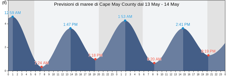
Martedì 23 aprile 2024, 09:44 EDT (GMT -0400). Adesso a Cape May County la marea è in discesa. Come si può vedere dal grafico, la marea più alta di 4.92ft è alle 21:18 e la marea più bassa di 0ft è stata alle 02:55 Clicca qui per vedere gli orari delle maree di Cape May County per questa settimana.

La prossima alta marea

La prossima alta marea è alle
21:18

Prossima bassa marea

La prossima bassa marea è alle
15:01

Tavola delle maree Cape May County

Tavola maree Cape May County questa settimana
Giorno Tavola delle maree Cape May County Alba e tramonto
1ª marea 2ª marea 3ª marea 4ª marea
mar 2302:55
0 ft
08:59
4.27 ft
15:01
0.33 ft
21:18
4.92 ft
06:10 19:45
mer 2403:35
0 ft
09:34
3.94 ft
15:37
0.33 ft
21:49
4.92 ft
06:09 19:46
gio 2504:14
0 ft
10:09
3.94 ft
16:11
0.33 ft
22:21
4.59 ft
06:08 19:47
ven 2604:52
0 ft
10:45
3.94 ft
16:44
0.33 ft
22:54
4.59 ft
06:06 19:48
sab 2705:31
0.33 ft
11:26
3.61 ft
17:18
0.66 ft
23:35
4.59 ft
06:05 19:49
dom 2806:11
0.33 ft
12:14
3.61 ft
17:57
0.66 ft
06:04 19:50
lun 2900:25
4.59 ft
06:58
0.33 ft
13:10
3.61 ft
18:45
0.98 ft
06:03 19:51

Orari migliori per pescare a Cape May County oggi Giornata eccezionale per la pesca

Maior horário de pesca

Dalle 06:13 alle 08:13

Transito lunare contrario (Luna sotto)

Dalle 18:44 alle 20:44

Transito lunare (Luna sopra)

Menor horário de pesca

Dalle 05:22 alle 06:22

Tramonto della luna

Dalle 19:14 alle 20:14

Sorgere della luna

Clicca qui per vedere meteo pesca per Cape May County questa settimana.

Tempo attuale a Cape May County

Parzialmente nuvoloso

Tempo metereologico

Coperto dalle nuvole 3%
Temperatura

Temperatura

52°F
Min 47°F/Max 52°F
Vento

Vento

8 mph
Raffica di vento 11 mph
Umidità

Umidità

55%
Punto di rugiada 36°F

Clicca qui per vedere il tempo di Cape May County per la settimana

Il tempo oggi a Cape May County

Il sole è sorto alle 06:10 e il tramonto sarà alle 19:45. Ci saranno 13 ore e 35 minuti di sole e la temperatura media è di 50°F. In questo momento la temperatura dell'acqua è di 49°F. e la temperatura media dell'acqua è di 49°F.

Tempo per Cape May County oggi
0 h 3 h 6 h 9 h 12 h 15 h 18 h 21 h 24 h
Parzialmente nuvolosoParzialmente nuvolosoParzialmente nuvolosoParzialmente nuvolosoParzialmente nuvolosoParzialmente nuvolosoParzialmente nuvolosoParzialmente nuvolosoParzialmente nuvoloso
48°F52°F47°F52°F51°F51°F47°F51°F52°F

Clicca qui per vedere il tempo di Cape May County per la settimana

Ulteriori previsioni di maree e informazioni marine per Cape May County

Regioni e città di Cape May County, New Jersey, United States

2nd BeachCorson's Inlet EntranceOld Turtle Thorofare
AvalonCorsons Inlet EntranceOld Turtle Thorofare RR bridge
Bay Shore Channel (city of Town Bank)Corsons Inlet State Park (Strathmere)Rio Grande
Bay Shore Channel (north)Delaware Bay EntranceSea Isle City
Beesleys PointDennis Creek (2.5 NM Above Entrance)Sluice Creek (Route 47 Bridge Dennis Creek)
Bidwell Creek (Route 47 Bridge)Dennis Creek (Route 47 Bridge)Sluice Creek Route 47 Bridge Dennis Creek
Bidwell Creek EntranceDennis Creek 2.5 N.Mi. Above EntranceStites Sound
Bidwell Creek Route 47 BridgeDennis Creek Route 47 BridgeStockton Avenue
Brandywine Shoal LightDias CreekStone Harbor (Great Channel)
Brandywine Shoal Light 0.5nm west ofDias Creek Route 47 BridgeStone Harbor Great Channel
Brandywine Shoal Light BayEast Creek (Route 47 Bridge)Strathmere (Strathmere Bay)
Cape Henlopen 2 miles northeast ofEast Creek Route 47 BridgeStrathmere Strathmere Bay
Cape Henlopen 4.8 n.mi. northeast ofErmaSwain Channel (Taylor Sound)
Cape Henlopen 5 miles north ofFive Fathom Bank Traffic LaneSwain Channel Taylor Sound
Cape Island CreekGreat Sound west sideTownsend Sound
Cape Island Creek (Cape May)Hereford InletTownsends Inlet
Cape Island Creek Cape MayHerring PointTuckahoe (Tuckahoe River)
Cape MayHigbee BeachTuckahoe Tuckahoe River
Cape May (Atlantic Ocean)Ingram ThorofareUpper Township (Petersburg)
Cape May Atlantic OceanJenkins SoundVillas
Cape May Canal east endLong Reach (Ingram Thorofare)Villas (Lower Township)
Cape May Canal west endLong Reach Ingram ThorofareWest Cape May
Cape May ChannelLudlam Bay (West Side)West Creek (0.7 NM Above Entrance)
Cape May Court HouseLudlam Bay West SideWest Creek 0.7 N.Mi. Above Entrance
Cape May ferry terminalMcCrie ShoalWest Wildwood (Grassy Sound)
Cape May HarborMiddle ThorofareWest Wildwood Grassy Sound
Cape May Harbor entranceMiddle Thorofare Ocean Drive BridgeWhitesboro-Burleigh
Cape May Point (Sunset Beach)New JettyWildwood
Cape May Point 1.4 n.mi. SSW ofNorth Cape MayWildwood Crest
Cape May Point 2.7 n.mi. SSW ofNorth Highlands BeachWildwood Crest (Ocean Pier)
Cape May Point Sunset BeachNorth WildwoodWildwood Crest Ocean Pier
Cedar Swamp Creek (Tuckahoe River)Nummy Island (Grassy Sound Channel)Wildwood Crest Sunset Lake
Cedar Swamp Creek Tuckahoe RiverNummy Island Grassy Sound ChannelWoodbine
Cooks BeachOcean City
Corson InletOcean Drive Bridge