Maree di Chatham County, Georgia, United States

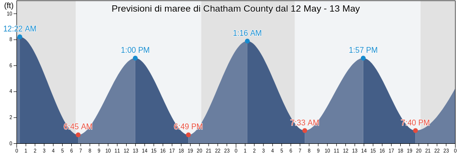
Venerdì 19 aprile 2024, 01:19 EDT (GMT -0400). Adesso a Chatham County la marea è in salita. Come si può vedere dal grafico, la marea più alta di 7.22ft è alle 19:00 e la marea più bassa di 0.98ft è stata alle 00:18 Clicca qui per vedere gli orari delle maree di Chatham County per questa settimana.

La prossima alta marea

La prossima alta marea è alle
06:23

Prossima bassa marea

La prossima bassa marea è alle
12:43

Tavola delle maree Chatham County

Tavola maree Chatham County questa settimana
Giorno Tavola delle maree Chatham County Alba e tramonto
1ª marea 2ª marea 3ª marea 4ª marea
ven 1900:18
0.98 ft
06:23
6.89 ft
12:43
0.98 ft
19:00
7.22 ft
06:50 19:57
sab 2001:06
0.66 ft
07:11
7.22 ft
13:22
0.66 ft
19:44
7.55 ft
06:49 19:57
dom 2101:50
0.66 ft
07:54
7.22 ft
13:59
0.66 ft
20:23
7.87 ft
06:48 19:58
lun 2202:32
0.33 ft
08:34
7.22 ft
14:35
0.33 ft
20:59
8.2 ft
06:47 19:59
mar 2303:12
0.33 ft
09:11
7.22 ft
15:11
0.33 ft
21:32
8.2 ft
06:46 19:59
mer 2403:51
0.33 ft
09:46
7.22 ft
15:47
0.33 ft
22:05
8.2 ft
06:45 20:00
gio 2504:29
0.33 ft
10:20
7.22 ft
16:23
0.33 ft
22:37
8.2 ft
06:44 20:01

Orari migliori per pescare a Chatham County oggi Giornata media per la pesca

Maior horário de pesca

Dalle 02:51 alle 04:51

Transito lunare contrario (Luna sotto)

Dalle 15:18 alle 17:18

Transito lunare (Luna sopra)

Menor horário de pesca

Dalle 04:17 alle 05:17

Tramonto della luna

Dalle 15:48 alle 16:48

Sorgere della luna

Clicca qui per vedere meteo pesca per Chatham County questa settimana.

Tempo attuale a Chatham County

Parzialmente nuvoloso

Tempo metereologico

Coperto dalle nuvole 42%
Temperatura

Temperatura

71°F
Min 68°F/Max 76°F
Vento

Vento

11 mph
Raffica di vento 19 mph
Umidità

Umidità

83%
Punto di rugiada 66°F

Clicca qui per vedere il tempo di Chatham County per la settimana

Il tempo oggi a Chatham County

Il sole sorgerà alle 06:50 e il tramonto sarà alle 19:57. Ci saranno 13 ore e 07 minuti di sole e la temperatura media è di 73°F. In questo momento la temperatura dell'acqua è di 66°F. e la temperatura media dell'acqua è di 66°F.

Tempo per Chatham County oggi
0 h 3 h 6 h 9 h 12 h 15 h 18 h 21 h 24 h
Parzialmente nuvolosoParzialmente nuvolosoParzialmente nuvolosoParzialmente nuvolosoParzialmente nuvolosoParzialmente nuvolosoParzialmente nuvolosoParzialmente nuvolosoParzialmente nuvoloso
71°F74°F72°F74°F76°F74°F72°F72°F71°F

Clicca qui per vedere il tempo di Chatham County per la settimana

Ulteriori previsioni di maree e informazioni marine per Chatham County

Regioni e città di Chatham County, Georgia, United States
2nd Street (Tybee Island)Fort Mcallister (Ogeechee River)Raccoon Key
610 Statute Mile MarkFort McAllister Ogeechee RiverRange A Light Bear River
Beach HammockFort PulaskiRomerly Marsh Creek
Bear River EntranceFort Pulaski 1.8 miles aboveS C L Rr Bridge
Bloody Point (Daufuskie Island)Fort Pulaski 4.8 miles aboveS.C.L. Rr. Bridge
Bloody Point Daufuskie IslandGood Hope Landing (South Of)Savannah
Bloody Pt. 0.5 mile north of New RiverGood Hope Landing South OfSavannah Bull Street
Bloody Pt. 0.5 mile west of New RiverGreys IslandSavannah River Entrance (between jetties)
Bradley Point (Bradley River)Hargray Pier (Daufuskie Island)Savannah River Entrance Fort Pulaski
Bradley Point Bradley RiverHargray Pier Daufuskie IslandSavannah Sheraton Resort Hotel
Bradley Point NNE ofHighway Bridge (Ogeechee River)Savannah southeast of highway bridge
Bull River 2 miles below hwy. bridgeHighway Bridge Ogeechee RiverSeaboard Coast Line Railroad
Burnside Island SE of Burnside RiverIsle of HopeSkidaway Island
Burntpot Island west of Skidaway RiverIsle of Hope (Skidaway River)Skidaway Island N End Wilmington River
Butter Bean BeachIsle of Hope City SE of Skidaway RiverSkidaway Narrows
Cane Patch Creek EntranceIsle of Hope City Skidaway RiverSkidaway River north entrance
Coffee Bluff (Forest River)Isle Of Hope Skidaway RiverSouth Channel western end
Coffee Bluff Forest RiverJoe's CutSouth of Kilkenny Creek Entrance
Cook Landing CemeteryJoes Cut Wilmington RiverSouth Ossabaw Island Bear River
Daufuskie Landing (Daufuskie Island)Kilkenny Club (Kilkenny Creek)St. Catherines Sound Entrance
Daufuskie Landing Daufuskie IslandKilkenny Club Kilkenny CreekThunderbolt
Daufuskie Landing Light south ofKing Island west ofThunderbolt SE of Wilmington River
Delegal Creek MarinaKings Island Channel Savannah RiverTurnbridge Landing (Salt Water Creek)
Doughboy IslandLazaretto Creek Entrance N of Bull RiverTurnbridge Landing Salt Water Creek
Dutch Island SE of Skidaway RiverLittle Back River Hwy. 17 Back River S.C.Tybee Creek Entrance
Egg IslandsLittle Don Island east of Vernon RiverTybee Island
Elba Island Cut NE of Savannah RiverLittle Ogeechee River EntranceTybee Light
Elba Island NE of Savannah RiverLittle Ogeechee River Entrance north ofTybee South End Sand Bar
Elba Island west of Savannah RiverLittle Wassaw Island SW ofVernon R. 1.2 miles S of Possum Point
Entrance off Beach HammockLong Island NNE of Skidaway RiverVernon View
Entrance off Wassaw IslandLong Island south of Skidaway RiverVernon View (Burnside River)
Fields Cut (Wright River)McQueen Island CutWalls Cut Turtle Island
Fields Cut Wright RiverMontgomeryWassaw Island N of E end Wassaw Sound
Fig Island north of Back RiverMontgomery Vernon RiverWassaw Island SSW of
Florida Passage (Bear River)North EntranceWhitemarsh Island
Florida Passage (Ogeechee River)North of Big Tom Creek EntranceWilmington Island
Florida Passage (south)Northwest of Newell Creek EntranceWilmington Island SSE of Bull River
Florida Passage Bear RiverOatland Island north tipWilmington R. 0.5 mi. S of Turners Creek
Florida Passage N of Ogeechee RiverOdingsell River EntranceWilmington R. ent. south channel
Florida Passage Ogeechee RiverPelican PointWilmington River ent. off Cabbage Island
Fort JacksonPigeon Island SSE of Skidaway RiverWright R. 0.2 mile above Walls Cut
Fort Mc Allister Ogeechee RiverPort Wentworth 0.2 mile above